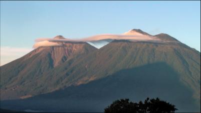
Acatenango
Location: 14.501° N, 90.876° W
Elevation: 3.976 m
The Fuego-Acatenango massif comprises a string of five or more volcanic vents along a north-south trend
that is perpendicular to that of the Central American
Volcanic Arc in Guatemala. From north to south, known
centers of volcanism are Ancient Acatenango,
Yepocapa, Pico Mayor de Acatenango, Meseta, and
Fuego. Volcanism along the trend stretches back more
than 200,000 years. Although many of the centers have
been active contemporaneously, there is a general
sequence of younger volcanism, from north to south
along the trend. This massive volcano complex towers
more than 3,500 metres above the Pacific coastal plain
to the south and 2,000 metres above the Guatemalan
Highlands to the north. The volcano complex comprises remnants of multiple eruptive centers, which
periodically have collapsed to form huge debris avalanches. The largest of these avalanches
extended more than 50 kilometres from its source and covered more than 300 square kilometres. The
only known historical eruption of Acatenango volcano occurred in the 20th century, between 1924 and
1927 from just north of the summit peak (Pico Mayor) and again in December 1972 from the saddle
between Yepocapa and Pico Mayor. These phreatic explosions generated ballistic volcanic bombs
that fell near the summit craters and fine volcanic ash that fell up to 25 km away. In prehistoric time,
Acatenango has erupted explosively to form widespread fall deposits, hot pyroclastic flows and lava
flows. There have been numerous eruptions during the past 80,000 years from vents along the
massif. The most recent explosive eruptions of Acatenango occurred 1,900 years ago (Pico Mayor),
2,300 years ago (Pico Mayor) and about 5,000 years ago (Yepocapa). If such eruptions were to recur,
many people and costly infrastructure would be at risk. (Wikipedia)
five or more volcanic vents along a north-south trend
that is perpendicular to that of the Central American
Volcanic Arc in Guatemala. From north to south, known
centers of volcanism are Ancient Acatenango,
Yepocapa, Pico Mayor de Acatenango, Meseta, and
Fuego. Volcanism along the trend stretches back more
than 200,000 years. Although many of the centers have
been active contemporaneously, there is a general
sequence of younger volcanism, from north to south
along the trend. This massive volcano complex towers
more than 3,500 metres above the Pacific coastal plain
to the south and 2,000 metres above the Guatemalan
Highlands to the north. The volcano complex comprises remnants of multiple eruptive centers, which
periodically have collapsed to form huge debris avalanches. The largest of these avalanches
extended more than 50 kilometres from its source and covered more than 300 square kilometres. The
only known historical eruption of Acatenango volcano occurred in the 20th century, between 1924 and
1927 from just north of the summit peak (Pico Mayor) and again in December 1972 from the saddle
between Yepocapa and Pico Mayor. These phreatic explosions generated ballistic volcanic bombs
that fell near the summit craters and fine volcanic ash that fell up to 25 km away. In prehistoric time,
Acatenango has erupted explosively to form widespread fall deposits, hot pyroclastic flows and lava
flows. There have been numerous eruptions during the past 80,000 years from vents along the
massif. The most recent explosive eruptions of Acatenango occurred 1,900 years ago (Pico Mayor),
2,300 years ago (Pico Mayor) and about 5,000 years ago (Yepocapa). If such eruptions were to recur,
many people and costly infrastructure would be at risk. (Wikipedia)


 HOME
HOME
